IDHE's Campus Boundaries Project
- NSLVE & Voting
- Collaborative Resources
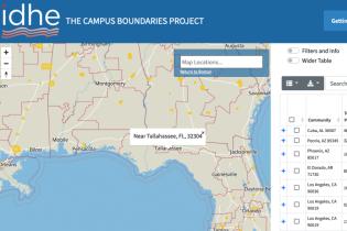
The Campus Boundaries Project allows users to see on a map where U.S. Congressional and state districts exist relative to college student communities of interest, where significant numbers of college and university students reside. This information is important because political districts define which elected officials a community can vote for. Therefore, how district lines are drawn determines each official’s electorate – the people to whom they are responsible. For more background on these topics and the purpose of the tool, see the “About this Project” tab on the Campus Boundaries Project website.
For further reading on the project and our analyses, read the accompanying data brief.